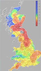
When I was playing with in-car systems at the AT&T Labs, we always wanted to do maps which were coloured according to the time it took you to get to a certain location, or distorted to show time rather than distance. We never got around to it, sadly. Fortunately, Chris Lightfoot and Tom Steinberg did.
They have all sorts of nice variations on the theme, too. The fact that much of it is based around Cambridge makes it particularly interesting for me.
Imagine a collaborative project where everybody is feeding their road speed into a central database and you can get this sort of data in real time, centred on your location, wherever you are. That would be a fun project for somebody…
And has anybody done this for the airlines, I wonder?
Thanks to John for the link.
Very useful map. I guess UK is a great place for testing the concept behind this project.
Hi,
I don’t know if this idea has already been considered, but if you could somehow map all the currently ‘input’ destinations for cars with Sat-nav you could see, real-time, what destinations people are heading for and overlay their routes on the map. This way you could plan your journey around the ‘busiest’ routes. Obviously not everybody has sat-nav, but from a purely informative point of you it could be quite interesting.
Paul